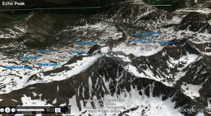
Google Earth pans into Yellowstone National Park, gliding effortlessly over mountaintops to reveal more mountaintops and finally landing upon an aerial view of a carefully preserved natural space. A click on the tour guide option spins a 360 degree view focusing on Echo Peak, the mountainous range is endless and vast. Each peak connecting to the next with rigid lines, softened by a blanket of snow, white and untouched except by nature, defined by the shadows growing out from underneath and flowing along the banks of the mountains.
Using the scroll bar to zoom in farther to ground level view displays a view of the mountains closer to the human perception. I seem to be covered in a thick layer of snow, right in the middle of two hills that seem to grow from the ground as the satellite view continues to form the curves of the terrain and the green, blue hue of the ground. Far into the distance I can discern more mountain peaks, shrinking as they go into the horizon line. The sky is unbounded, filled with gray-blue clouds, stretching across the screen. Sunshine peaks out from the horizon, light shines through the ominous forms in the sky. This is a sight barely seen by the world. At first, I feel overwhelmed by my immediate surroundings, but examining the image before me lets the elements settle in. The sky, the clouds, the mountains, snow, white, green, blue, all form into one. It is a strange feeling; a combination of tranquility and awe, somewhere between being on top of the world and nestled safely within its hands.
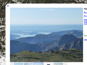
I click on the photos others added to the peaks, struck by the breathtaking images. They show not only the structures shown by Google Earth, but the individual characteristics that give it an identity. The ground the photographer is standing on, the layers of ridges blending as they reach the horizon, with a blue mist fading into the skyline. I can imagine the crisp breeze that comes through every twenty seconds, the serenity of the structures coming over me like a wave of inner peace. While the satellite pan of Echo Peak depicted the scale and vastness of the mountains, these photos truly enhance the features by providing the realistic view of nature. By using both the photos and the tour guide pans of the space, one can easily put together an overall sense of the architecture.
While Google Earth is a great tool to view different places, I also believe that textual visualizations can at times evoke feelings that images are unable to. The words written on a page give the reader the power of their own imagination, while the pixels in a photograph creates a still image. An amazing image will accurately display the area, but text can describe the smell of the trees, the beauty of the snow that glistens under the sun, or the sounds of the breeze tickling the leaves and the wind against ones skin. A good photo can also do these things, but I find that I am never as absorbed in another world when I am looking at an image than when I am reading a passage or book. Google Earth provides a decent representation of these natural spaces, but people are still conscious that they are sitting in a room looking at it on a laptop or an iPad. A textual virtualization has the ability to take one to another realm, many times even beyond reality. It can transport one away from society, and into the heart of nature.


Nice thoughtful response, Angela. Your focus on the specifics of using Google Earth in your first few paragraphs was well done, and I enjoyed you invocation of the sublime.